II. Dakota County, Minnesota
Why Dakota County?
Dakota County, Minnesota, is an example of multi-jurisdictional participation led by a county using a long-range planning approach to access management. They demonstrate success through the implementation of access management practices as development occurs throughout the county, rather than after the fact thus reducing future impacts to the traveling public, and future costs to Dakota County taxpayers.
A. Access Management Program
Dakota County's access management program employs many strategies to ensure the mobility and safety of the highway system. The contiguous plat ordinance, transportation plan, and right of way ordinance are the policies that Dakota County employs for access management. The implementation of those policies is carried out through corridor studies, development review process, permit process, and improvement projects.
The following list contains several key points from Dakota County's access management program.
- Their program has the advantage of being applied in a developing area-much of it is still developing, they have the opportunity to involve access management in advance of development.
- Their program only allows one access point per parcel on low volume roads for all non-conforming lots.
- Dakota County created an access spacing guide to help reduce and consolidate access in order to maximize operations, safety, and mobility. The guide addresses each highway type to better balance access and mobility.
- Dakota County identifies specific access locations and requires access control be placed on the parcel adjacent to the county highway whenever possible for corridor preservation through the plat review processes.
- The program aims to develop a complete network of streets and roads with consideration to future access management development.
- The program created restricted intersections that allow right in and right out turns but only left turns in. Due to the adverse impact on traffic safety and signal operations, the left turn out is not allowed. An example from CH 42 can be found on page 8.
- The program works to limit the number of signal locations along the corridor where appropriate to facilitate progression and minimize delay for the highway.
What Is It Enabled By?
The access management program is enabled by the following items:
- Dakota County has plat approval authority, giving them the ability to review and approve plats along the county highway system (Minnesota Statutes 383D.65 Subd 2) including proper location of property and public street access.
- The primary catalyst to the program is the contiguous plat ordinance, originally adopted in 1974 and updated in 2005, requiring right of way dedication for parcels along the county highway based on future needs.
- The contiguous plat ordinance established the Plat Commission, which reviews each plat and provides recommendations to the Board of Commissioners for final approval.
- The Plat Commission's objective is to work with cities and developers to provide a plan for access that is consistent with proper development of the surrounding roadway system and accommodates the development proposal in a safe and efficient manner.
- Plat review and approval involves evaluation of the access spacing, assessment of operations with respect to safety, and presence of roadway connections to proactively plan an integrated street network.
- The Dakota County 2025 Transportation Plan was approved in 2004 for Dakota County, its partners (Mn/DOT, cities, townships, regional agencies, and adjacent agencies), and citizens as a guide to maintain and improve the transportation system; support land goals and objectives; and document the transportation policies and strategies.
- The Dakota County 2025 Transportation Plan identifies major investments and prioritizes needs associated with preservation management, replacement, and transportation alternatives goals. The plan itself provides detail on planned access locations.
- The 2025 Transportation Plan includes a creative funding policy where the county can consider cost sharing for frontage and backage roads when the roadway connections will enhance mobility.
- A right of way ordinance was adopted in 2002 with current revisions being proposed that address access management and specific conditions for permits. Minnesota Statute 160.18 permits access to the highway for the abutting property owner subject to reasonable regulation by and permits from the road authority.
What Is Unique To Dakota County?
- Dakota County is the only county of 87 Minnesota counties with plat approval authority, explained above. The Plat Ordinance originally written in 1974 is provided in Appendix A. This ordinance was later amended by the Board of County Commissioners in 2005 and is attached as Appendix B.
B. Outcomes
Dakota County has successfully implemented access management practices early in the development process throughout the county, thus paving the way for continued work in access management. Spacing guidelines were created and have been implemented as planned. The following lists the outcomes in Dakota County:
- The program created access spacing guidelines to balance access and mobility, based on the function of the highway, planned highway type, and traffic volume.
- There was early identification of a contiguous corridor with agreement from all the jurisdictions that the corridor would be a thoroughfare and that access management would be the right approach to take.
- Dakota County has experienced very few corridor safety issues due to the access management practices that are successfully being applied.
- Dakota County restricts access along the county highway through the plat review process.
- The 2025 Transportation Plan restricted full access to locations one-half mile apart for the highest functioning county roadways.
- The restricted access intersections (eliminating minor street left turns and through movements) can drastically reduce crashes, and have had positive impacts on upstream and downstream signalized intersections. See picture on page 8.
- Counties have jurisdiction over some non-freeway principal arterials, minor arterials, and certain rural collector roadways, whether those roadways are in incorporated areas or not. This is different than in many states, where jurisdiction over local roadways is determined by whether the roadway is within an unincorporated part of a county, versus within a city or town. Townships and cities maintain the non-county collector streets.
1. Dakota County Example: Highway 42
County Highway 42 (CH 42) is an east-west, principal arterial running through Dakota and Scott counties. This multilane urban arterial roadway is an integral component of the regional roadway system for the metro area serving a number of major regional commercial districts and providing direct connections to all the major north/south principal arterials in the area. Key points from CH 42 are as follows:
- A corridor study was conducted to determine how to manage the primary function of this route to accommodate through traffic with the competing interests for access to abutting properties as subsequent development continues.
- The initial study took a comprehensive look at the entire corridor. Detailed studies have since been conducted on specific segments of CH 42 to resolve capacity and safety issues in more depth.
- For one major area of CH 42, the study expanded on the initial work to further evaluate existing traffic and safety conditions, and incorporated the businesses and public in the process to help develop a preferred alternative.
- The improvement plan included the removal of an existing signal, elimination of private driveways, creation of secondary access (restricting the left turn or through movement from the side road), construction of frontage or backage roads to allow area traffic and businesses to reach the main full access intersections, and the addition of lanes along the main line. See pictures on page 8.
- An extensive public involvement and business involvement plan were key to establishing agreement from abutting land owners and business regarding access location and spacing. The plan received approval from each city and county involved.
- To implement the overall plan, the county modified policy to cost share for frontage roads to ensure all elements of the corridor implementation would come to fruition.
- The corridor of CH 42 not only crosses the entire width of Dakota County, but also continues as a major east-west artery through adjoining Scott County. This corridor passes through several incorporated cities and towns in both counties. Thus, there are several government jurisdictions involved in land-use regulation affecting the corridor.
- A 1973 regulation passed by the State Legislature laid the groundwork for Dakota County's ability to implement access management along the entire contiguous Highway 42 corridor in Dakota County.
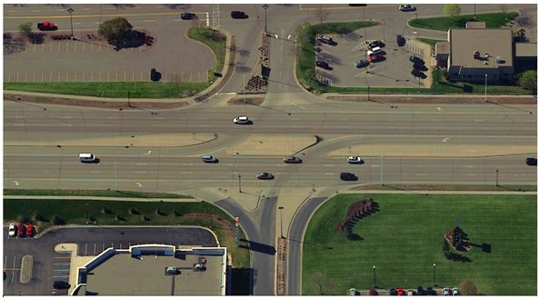
Picture: Apple Valley, Minnesota
Shows an example of a restricted access intersection.
© Regents of the University of Minnesota. All rights reserved. Used with permission.
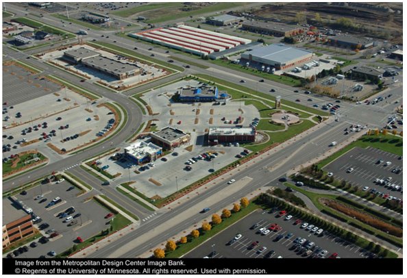
Picture: Apple Valley, Minnesota
Shows an example of backage roads used as alternative access for local businesses.
C. Lessons Learned
1. Successes
The major key to success with access management in Dakota County has been their proactive planning to involve access management as development occurs. Through this:
- Most of the access management that has been implemented was done proactively, in preventative style. A small amount of reactive, after-the-fact, retrofitting has been necessary.
- Access was managed as land conversion took place (from agricultural to residential and commercial) with foresight and long-range planning. Cooperation and agreement among the various jurisdictions made this possible.
- Dakota County has a comprehensive long-range plan that covers the entire contiguous length of each highway. A contributing factor is that they have plat review authority within incorporated and unincorporated areas over land development elements that have effects on the roadway.
- The intersection configuration to restrict left turn/through traffic seems to be a good device for application in most areas. This is an example of access management applied in a "new-build" development situation.
- The county highway system is working to serve motorists in a safe and efficient manner; this is due to their county's access management plan.
2. Challenges
The following list contains several of the challenges Dakota County experienced resulting from their access management program.
- Some access management seems to be constrained by state legislation that sets the method of compensation for right of way and defines access denials as "takings."
- Minnesota law seems to contribute to the possibly excessive cost in purchasing access rights.
- While management strategies do provide for consistent access control as development occurs, development pressures exist for more access on the system than may be allowed.
- There are instances where the standards may not be feasible on an interim or long term basis and variances are considered. The full access on Route 42 in Rosemount is over one mile and scan tour participants suggest that this may be too great to keep platoons of cars together for traffic signal progression. The distance may be too great to keep platoons of cars together, which optimizes signalization.
- Dakota County's emphasis is in moving traffic while still recognizing the balance with access along the road.
3. If We Had It To Do Over Again...
- If Dakota County were able to redevelop the access management program from the very beginning, they would consider the following:
- Dakota County would plan a well-spaced (1-2 miles) system of east/west and north/south arterial roadways before development occurred. The difficulty with this is convincing the public that the long-term mobility and safety benefits outweigh the short-term costs and implication to specific development proposals.
- The county would put more effort into existing minor arterial road planning in developing areas. Such planning wouldn't have stipulations on spacing.
- The program would include future intersection locations and how these roads fit into a system of principal arterials and collector streets before development proposals limit roadway system options.
4. Risks Going Forward
Dakota County sees the following items as risks to the program:
- Dakota County, unlike any other county in Minnesota, has the ability to review and approve plats along the county highway system. This authority has been a key to implementation and the county needs to provide advocacy for its benefits.
- Maintaining a relationship with the county board will be very important. Assure that the board knows how Dakota County does things and that the board supports their efforts.
- The relationships and level of communication between the roadway authorities and the land use authorities has direct implications on the successes and failures of the transportation system.
5. Other Background
Additional background information is listed as follows:
- The county's access spacing guidelines were developed and utilized for over 20 years. The first transportation plan, adopted in 1982, incorporated requirements for private access to city streets based on the functional needs of the highway system. While the county has the authority to modify median access as necessary to ensure the safety and operation of the highway, the spacing document aims to proactively identify where the major access points should be along the highway system to best manage operation as a whole.
- The county utilizes the 2005 Dakota County Road Plat Review Needs Map to identify the long term right of way needs. The Needs Map is developed by the county and maintained in coordination with cities and townships. This countywide Needs Map establishes right of way width for plat dedication and information associated with access spacing guidelines.
- The Needs Map, based on traffic projections and highway functions, is reevaluated each year based on changes in future corridor needs, consistency with policy objectives, intermodal potential, and coordination with adjacent land use. If area development deviates from the city's comprehensive plan, the future highway needs may be greater than previously projected. Likewise, anticipated new roadway corridors may change the traffic patterns and highway needs of nearby roads in a less intensive manner, reducing the need for lanes and right of way. Reviewing the Needs Map annually with the local government units allows county staff to be responsive to the future needs based on the current projections and available land use information.
- The Plat Commission process is a critical tool in ensuring a well-designed access management plan when reviewing plats. The plat ordinance details the following seven factors of countywide importance; the plat review revolves around ensuring compliance with these factors. The commission reviews each plat for adherence to the contiguous plat ordinance based on factors relating to safety, access, and right of way needs:
- Ingress/egress to and from the county roads - access to the site.
- Approach grade for intersections - assessment of sight distance and reasonable grade of the access.
- Drainage - ensure run-off from the plat is dealt with onsite and will not create ponding or flooding outside of the plat area.
- Safety standards - Ensure safe operation for development access and the highway. This assessment includes checking for any safety issues including adequate sight distance, capacity, weaving, or conflicting traffic concerns, and traffic operation at the access point.
- County road right of way requirements - Dedication of right of way based on the identified future highway needs.
- Local road system integration with the county road system - Assessment of how the local streets work with the county roadway to provide a network of streets to serve the mobility and access needs appropriately based on each road's function.
- Land use impact of development on the county road system - Understanding of the planned use for the proposal including the amount of traffic anticipated to be generated from the site and corresponding demand at the site's access and nearby intersections.
6. Team Conclusions
The following are conclusions made by our team about the access management program in Dakota County, Minnesota.
- Dakota County provides a textbook example of an effective multi-disciplinary, multi-jurisdictional approach to building sound access management principles into the development of the county road system and land development.
- Creating new state policies that help to fund frontage and backage roads is a very creative solution that enhances mobility.
- The use of restricted intersections has positive impacts on traffic at upstream and downstream signalized intersections.
7. Important Links
- The Dakota County 2025 Transportation Plan can be found at: http://www.co.dakota.mn.us/planning/Transportation/Transportation%20Plan.pdf
- Contiguous Plat Ordinance. Dakota County, 1974. Accessible via
- http://www.dakotacounty.us/survey/pdf/surveymanuals/Plat%20Ordinance.pdf
- Dakota County Plat Commission Webpage: http://www.co.dakota.mn.us/survey/info/platcomm.htm
- Access Management Policy: Access Category System and Spacing Guidelines. Office of Investment Management, State of Minnesota, 2002. Accessible via http://www.oim.dot.state.mn.us/access/policy.html
- Dakota County Ordinance No. 126. Dakota County, 2001. Accessible via http://www.dakotacounty.us/highway/pdf/Ordinance%20126.pdf
- Minnesota Statue 383D.65. Office of Revisor of Statues, State of Minnesota, 2005. Accessible via http://www.revisor.leg.state.mn.us/st05/383D/65.html
- Minnesota Statue 160.18. Office of Revisor of Statues, State of Minnesota, 2005. Accessible via http://www.revisor.leg.state.mn.us/data/revisor/statutes/2005/160/18.html
- East-West Corridor: http://www.dakotacounty.us/planning/Transportation/eastwest/index.htm
- Highway 42 Corridor: http://www.dakotacounty.us/highway/design/42-91.htm